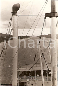
20th September 1939
Panama Canal - Lock
Photo shows an electric locomotive at work while towing a ship into the locks.
Fotografia d'epoca della locomotiva elettrica che traina una nave nella chiusa ("mule" in gergo marittimo..
Vera fotografia d'epoca, originale e autentica, completa di timbro datario e di nota manoscritta al verso.
In buone condizioni
--------------------
Note: The Panama Canal, begun in 1904 and finished in 1914, is a 77 km (48 mi) ship canal in Panama that joins the Atlantic Ocean and the Pacific Ocean and is a key conduit for international maritime trade. Annual traffic has risen from about 1,000 ships in the canal's early days to 14,702 vessels in 2008, measuring a total 309.6 million Panama Canal/Universal Measurement System (PC/UMS) tons.
One of the largest and most difficult engineering projects ever undertaken, the canal had an enormous impact on shipping between the two oceans, replacing the long and treacherous route via the Drake Passage and Cape Horn at the southernmost tip of South America. A ship sailing from New York to San Francisco via the canal travels 9,500 km (5,900 mi), well under half the 22,500 km (14,000 mi) route around Cape Horn.
The concept of a canal near Panama dates to the early 16th century. The first attempt to construct a canal began in 1880 under French leadership, but was abandoned after 21,900 workers died, largely from disease (particularly malaria and yellow fever) and landslides. The United States launched a second effort, incurring a further 5,600 deaths but succeeding in opening the canal in 1914. The U.S. controlled the canal and the Canal Zone surrounding it until the 1977 Torrijos-Carter Treaties provided for the transition of control to Panama. From 1979 to 1999 the canal was under joint U.S.-Panamanian administration, and from 31 December 1999 command of the waterway was assumed by the Panama Canal Authority, an agency of the Panamanian government.
While the Pacific Ocean is west of the isthmus and the Atlantic to the east, the 8- to 10-hour journey through the canal from the Pacific to the Atlantic is one from southeast to northwest. This is a result of the isthmus's "curving back on itself" in the region of the canal. The Bridge of the Americas at the Pacific end is about a third of a degree of longitude east of the end near Colon on the Atlantic.
The maximum size of vessel that can use the canal is known as Panamax.
